


History of St Peters River Park - Land Division
3.0 Land Division & Classification
St Peters River Park is in the Hundred of Adelaide and the Hundred of Yatala in the County of Adelaide. This includes Section 258, Section 257 and Section 475.
In the early days of European settlement in South Australia, the purchase of land was released in the province in an orderly manner by the British Government and was considered the property of the Crown.
Unlike other colonies, in the Province of South Australia land was not to be given away but was to be surveyed and sold systematically at a minimum price intended to encourage people with capital to make South Australia their new home. This was part of the Wakefield Plan.
Initial land sales were made as a prerequisite to the founding of the Province of South Australia by the issuing of preliminary land orders in Britain prior to 1837. The holders of these preliminary orders could take first choice of land when it had been surveyed and present their orders to the Resident Commissioner in the Land Office, to receive their title deeds or "land grants".
The initial town survey of Adelaide was completed in March 1837 by Colonel Light, and by February 1839 the surrounding country to the east had been surveyed into what were called Country Sections.
The colonial surveyors made sure that wherever possible boundaries of these Sections abutted, crossed or centred upon a stretch of river or creek ensuring that it raised the monetary value of the land. This was clearly the case with the River Torrens and its five creeks.
According to Dr Rob Amery, University of Adelaide (2009), the Hundred of Yatala was derived from the name for the River Torrens as it was called ‘Yartala’ by the Kaurna people while in flood.
Colonel Light’s survey map of 1839 clearly shows that the River Torrens and the oxbow bend (now part of the St Peters River Park) was an important topographical consideration influencing the surveyors’ delineation of Sections 257, 258 and 475.
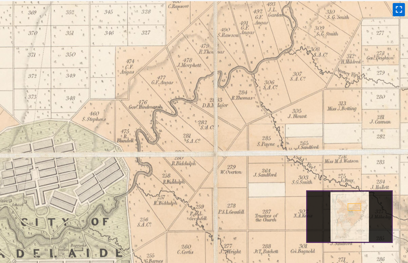
Fig2 The District of Adelaide, South Australia, as divided into Country Sections from the trigonometrical surveys of
Colonel Light, Surveyor General, published by John Arrowsmith, 35 Essex St., London, 1839.