Planning System Review (2023) Submission
The submission is available as a PDF.
General Comments
General loss of detail in the Code compared to Development Plans
The Code has over-simplified policy requirements, which means that a planner assessing a development application has less options for negotiating good design outcomes.
Loss of land division policy occurred in the transition to the Code. Our Norwood Payneham and St. Peters (NPSP) Council controlled subdivisions in small localities where subdivision was considered undesirable. This allowed Council to direct subdivision and increased densities to more appropriate locations. The loss of detailed control has led to minimum size Technical Numerical Variations being increased for individual streets to prevent subdivision. This is less satisfactory than Development Plan policy which provided clear instruction and intent, as our Council has pointed out in its submission to you.
Code Amendments
At present it is very difficult for individual councils to gain approval for Code Amendments. The private sector is now dominating the Code Amendment program, and this results in outcomes which are not driven by strategic planning considerations or policy improvements. Rezoning isolated sites results in less certainty and clarity for the community. We submit that it needs to be made simpler for councils to gain approval for variations to Code policies for their areas.
Standardised codes and policies on a “one size fits all” approach is a recipe for poor quality development. Our council has suggested more subzones be allowed to permit local policy detail to be allowed in the Code, and we support this.
Difficulty in using the on-line Code
The On-Line Code process needs to be improved so that it is easier for the public and practitioners to use. It is quite complex for the public to look up zones and then have to look up overlays. The NPSP Council has detailed some of these problems in its submission, and we support these suggestions.
Significant Development Sites
Community confidence in the planning system is undermined by inconsistencies in development decisions. Recently SCAP approved an 8-storey mixed use development for 120 The Parade Norwood as a Significant Development Site. This is in a part of The Parade zoned for a maximum height of six storeys under TNV DPF3.1 Urban Corridor (Main Street) Zone. Minimal front setbacks of multi-storey apartments from the street are an unfortunate aspect of this development which is to be built above small heritage shops. The extra height allowed is also unfortunate. Set on three amalgamated sites, the excessively large building approved will be out of scale with anything else in its vicinity on this main shopping strip, undermining the High Street quality of The Parade with its emphasis on intimate human-scale shopping facilities.
We submit that development of Significant Sites frequently contravenes good planning outcomes, lacks consistency in planning decisions and is often anathema to the general public. We submit that this special category of multi-storey development should be removed from the Code.
Extra (bonus) heights
We submit that allowing extra heights for multi-storey buildings on the grounds that an applicant includes at least three desirable features (re-use of historic building, 15% affordable housing, public realm treatment, high quality open space, high quality pedestrian linkages, activation at ground floor, 10% 3 bedrooms, childcare centre, vertical garden, increased open space) undermines certainty for neighbours of such developments. Allowing extra height undermines community trust in the planning system. Surely developers do not need to be bribed to include desirable features in their developments. They will be able to reap the economic benefits of providing high quality features. Local communities should not have to pay for these indulgences for developers. To allow such developments to proceed lacks strategic insight and provides an example of opaque (ie non transparent) decision-making, leaving many in our community scratching their heads. It creates great uncertainty and stress for the near neighbours of such developments.
When former Planning Minister John Rau conducted a spot rezoning of the Hackney Hotel site, there was extensive public consultation with the community. As a result of this, the maximum height for development on this site was specified as 4-storeys and many of us breathed a sigh of relief. However, when this property was re-developed several years later, a 7-storey apartment and serviced rooms complex was approved by SCAP. Community trust in the planning system was gravely undermined.
Relevant Authorities
The Planning Development and Infrastructure Act has created a complex system of different authorities. The public is often bewildered as to which planning authority is responsible for which development decision, and the local council is often unfairly blamed for a decision not of its making.
We submit that the assessment of development applications over 4 stories in height should be returned to the NPSP Council, rather than being assessed by the State Commission Assessment Panel (SCAP). Our council has a greater knowledge than does SCAP of the history of different localities, the opportunities and constraints on multi-storey developments, traffic issues and heritage issues. Its planners are well qualified to deal with multi-storey development applications.
Council Assessment Panels
We submit that in their present form Council Assessment Panels suffer from a democratic deficit in that only one elected councillor is allowed to sit on the panel, along with three independents and an independent chairman. Councillors know more about their local communities, particularly local history, than independents do, and their knowledge should be used more in assessing development applications. We submit that Council Assessment Panels should be permitted to comprise two councillors, two independents and an independent Chair. Elected members are no more “biased” than the ”independent” representatives of the development industry usually appointed to the Panel.
We also submit that the name of the panel should not include the word “Council” as this unfairly suggests that the Council has approved the development. The former name of Development Assessment Panel, or even Independent Development Panel may be more appropriate.
Greater setbacks for multi-storey flats on roads
The 7- storey mixed use development being built on the former Caroma site on Magill Road Norwood has inadequate front setbacks for the residential apartments from a major roadway which carries over 24,000 vehicles a day. Minimal street setbacks result from poor development decisions. Two storey podiums are acceptable but above this a greater setback from the road is desirable to reduce the visual dominance of such buildings when viewed from the street they face, and to create a more pleasant (less noisy and polluted) environment for the residents who will live in these buildings. 120 The Parade Norwood is another recent development approved by the State Commission Assessment Panel which has minimal setbacks for apartments from the roadway. In this case, lack of sufficient street setbacks will mean this 8-storey building will overwhelm the small heritage shops built at ground level.
Issues Raised by Expert Panel
Public Notification and Appeals
We submit that the public should be notified where the Code maximum building heights are proposed to be exceeded. In principle, any development which exceeds policy parameters should be publicly notified.
We support the restoration of third-party appeal rights for developments which exceed maximum building height Code policies, in the interests of a transparent and accountable planning system.
Deemed Consents
We submit that allowing council planners only 20 business days to deal with a development application before an application automatically becomes a “deemed consent” is not fair. Often planners need to seek more information from applicants. Issues of stormwater, significant trees, road traffic issues and so on may need to be referred to different staff in other parts of the council and/or to external bodies such as the Department of Road Transport or specialist consultants for comment. All these issues take time.
Increased pressure on planning staff in the NPSP Council has contributed to staff resignations in the past 18 months.
Deemed consents may result in poor quality development. They seem a reckless concept to us. In any event, more time should be allowed to councils to assess development applications.
Elevate Character Areas to Historic Areas
The State Planning Commission proposes to elevate Character Areas to Historic Areas by helping councils to undertake Code Amendments to ensure this. The Expert Panel supports this. We strongly support this proposal also. The Commission will need to provide guidelines to councils on how proposed upgrades will be assessed.
Character Area and Historic Area Statements
The Commission proposes to support and facilitate councils to review and update their Character Area Statements and Historic Area Statements. We understand the Expert Panel supports this. We strongly support this proposal.
Desired Character Statements which existed in the NPSP Development Plan provided a detailed vision of the character and desired future development options for residential zones in Character and Historic Overlay areas. The loss of this detail in the transition to the Code was unfortunate, and it is most encouraging that both the Commission and the Expert Panel now accept this. We welcome improvements to the Code.
Greater planning policy detail allows planning assessors to guide applicants more easily to ensure good quality development, while at the same time ensuring that valued character and qualities receive adequate protection. We submit that the content of Desired Character Statements should be included in the Code, not just for residential areas but also for commercial and mixed-use areas.
Representative Buildings were included in the Code as a result of the community and councils advocating for the continued protection from demolition of Contributory Items in council Development Plans. There is a vague description of Representative Buildings in the Code as “buildings which display characteristics of importance in a particular area”. Apart from this and a short reference in Historic Area Statements, Representative Buildings are not mentioned in Code policies. For example, demolition policy in the Historic Overlays Area does not mention them. This leads to confusion among planners and the general public. The NPSP Council provides alternative policy wording to more clearly communicate the intent and purpose of Representative Buildings to provide more certainty for both property owners and relevant authorities (see Attachment 2 NPSP submission). We support this.
Tougher demolition Controls in Character areas
We support the proposal that demolition of a building in a Character Area (and Historic Area) should only be allowed once a replacement building has been approved. While not perfect as building plans may change, we believe this proposal will help to reassure the community that demolition in these areas is under better control.
Infill Policy
The Commission document states that “It is important that greater attention is now paid to where infill policies are spatially applied to make sure that the Code has the right policies in the right locations”.
South Australia, and in particular Adelaide, needs a Regional Plan to show what sort of housing development is to go where. We hold long-term concerns that the 30 Year Plan for Greater Adelaide lacks detail about housing densification while indicating that infill housing can occur when major transport routes are nearby. This has the potential to decimate much of our council’s Historic Overlay Areas. Lack of a comprehensive Regional Plan has created uncertainty and we submit that this must be addressed as a matter of some urgency.
Infill housing design guidelines have been improved in the Code, but more nuanced design guidelines would improve housing outcomes. Double garages on narrow allotments do not generally result in attractive streetscapes or good design, particularly where they comprise more than 50% of the frontage. They also limit the ability of councils to plant street trees.
More nuanced design guidelines should be provided for two-storey development (both new dwellings and dwelling additions).
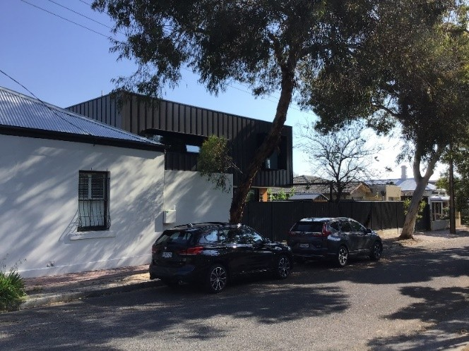
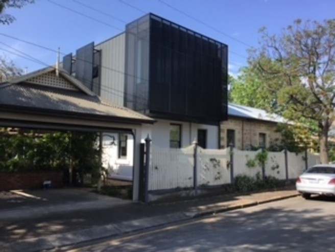
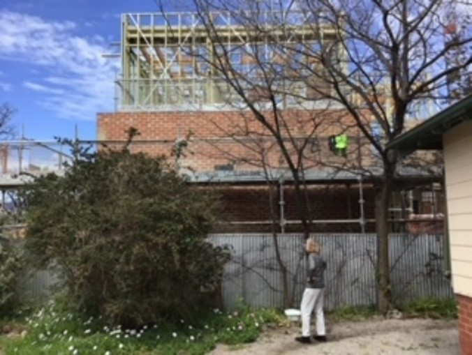
In established Character Overlay Areas and Historic Overlay Areas, large two-storey rear extensions, frequently flat-roofed and painted black, have aroused community concerns for some years in our council area, with the amenity of adjacent neighbours a major issue. The following photos are examples of recent two-storey house extensions in Historic and Character Areas in the NPSP Council area.
We submit that development fronting laneways in the St Peters Historic and Character Overlay areas does not generally result in good development.
The former NPSP Development Plan contained clear policy regarding which laneways could and could not serve as a primary frontage for dwellings. This policy was to ensure dwellings had appropriate access to essential infrastructure services. Most of the laneways in the former St Peters Council area formed part of the original subdivision layout in the mid-1870s. These lanes were for rear property and night-cart access and have narrow (4.2m) lightweight pavements. They also do not have services including power, water, gas, phone/NBN, storm water, street lighting, and are too narrow for modern garbage collection vehicles with robotic arms.
Some recent infill residential developments facing First Lane, St Peters are causing traffic congestion and parking problems, not only on First Lane, but also affecting access and egress onto Payneham Road, Stephen Terrace and First Avenue. This will be exacerbated by the recently approved mixed-use four-story development at 151-157 Payneham Road St Peters adjacent to the existing Jam factory apartments.
Alternative forms of infill development could include row dwellings, semi-detached dwellings and converting large historic dwellings to separate apartments. We submit that backyard developments such as hammer-head and battle-axe sub-divisions often result in sub-optimal living conditions both for residents and for neighbours, in terms of extra noise for neighbours (vehicles, leaf-blowers, slamming doors etc), loss of trees and vegetation, loss of biodiversity, loss of green landscape views, extra heat in summer, large blank walls facing neighbours.
We note that the Commission has a booklet out on an option for aged housing being in the form of granny flats in backyards. We submit that the loss of trees and vegetation resulting from the widespread use of granny flats may work against the tree canopy targets and biodiversity targets for SA.
Local Heritage Places
We do not support Local Heritage Places being placed under the control of a Heritage Authority. While some councils perform better than others in protecting local heritage, we consider this is best left in the hands of local communities and their representatives.
Historic Overlay Areas subject to popular vote
We are strongly opposed to requiring any new Historic Overlay Area to be supported by a majority vote. No other planning policy mechanism is subject to “popular vote”. Indeed, citizens were never asked whether they supported the urban infill policies of State Governments over the past 30 years. It is unfair to inflict on Historic Overlay Areas a burden which no other planning policy mechanism has been subjected to.
We submit that Clauses 67(4) and 67(5) of the PDI Act should be deleted.
Trees
Tree canopy in South Australia should be protected and increased. Climate change is making our summers generally hotter. Infill housing which demolishes dwellings and gardens to build dense infill units is contributing to the tree loss in Adelaide.
Large new dwellings with high site coverage are also contributing to the loss of urban trees. A 50 per cent site coverage allows a large new house to be built in the middle of a site and the only open space around the new dwelling consists of narrow pieces along the sides of the new dwelling, a front garden and a small or no back garden. Front setbacks are often mandated in the Code but rear setbacks less so. Many new houses are being built without back gardens. This is a tragedy for young families with children and a great loss for our trees and urban wildlife (See “The Life and Death of the Australian Backyard” by Tony Hall (CSIRO, 2014)). Large rear extensions, outdoor kitchens and swimming pools are also contributing to the loss of backyard trees on private property. There needs to be a mandated minimum pervious/permeable area specified for suburban allotments and minimum rear setbacks to ensure adequate vegetation and trees are planted. Researcher and author Tony Hall concludes from his nation-wide study of the loss of back-gardens over the past 20 years (p149) -
“The procedural solution would be very simple. Planning codes should specify rear setbacks of 8-10m, in the same way that they specify front setbacks of, say, 6m. They could also specify maximum plot coverage of 35%.”
These requirements could be varied somewhat to suit different allotment sizes and policy areas.
In well-established residential suburbs it is most distressing for many local residents to see old trees and well-established gardens clear-felled when a residential property is being re-developed. Developers prefer to clear all vegetation from a residential allotment to simplify their development. But does this mean that we, as a society, place no value on most established trees and gardens, which may have been lovingly attended for the past fifty to 100 years or more? What does this say about us as a society?
Developers can build around existing substantial trees on suburban allotments. This occurred when the tree protection laws first came into South Australia. However, when former Planning Minister John Rau watered down the tree protections several years later, more sites saw their trees and vegetation completely ripped out to permit development.
The requirement that trees must have a three metre or two metre circumferences (measured one metre from the ground) to qualify for some protection is too onerous. Most of SA’s trees will never reach this trunk size. We submit that half a metre trunk circumference for a Regulated Tree and one metre for a Significant Tree would be more appropriate. While this would generate more applications to councils to remove trees, the increase in protected trees would go a long way towards improving our tree canopy.
We submit that a range of factors should be considered when assessing whether a tree warrants protection as a Regulated or Significant Tree. These should include trunk size, canopy size, height, aesthetic contribution to streetscape, aesthetic contribution to neighbourhood amenity, contribution to the ecology of the local environment and contribution to summer shade and the sequestration of carbon dioxide. Trees also absorb airborne pollutants and help absorb the noise of motor vehicles but assessing these characteristics may be difficult. We question whether council planners have the expertise to assess whether a tree is important for the ecology of a local area and recommend more ecologists be employed by councils to help with this work.
We oppose the requirement that a Significant or Regulated Tree (apart from Eucalypts and Agonis flexuosa (Willow Myrtles)) can be cut down if they are within 10 metres of a dwelling or swimming pool. Few trees on suburban allotments are more than 10 metres from dwellings or swimming pools. We suggest that no fixed measurement should be specified in the Code for a Significant or Regulated Tree in order to escape from the threat of deliberate destruction by humans. Good footing design can deal with the issue of tree roots.
Current tests for removal of a Significant Tree include the health and structure of the tree, the risk to people and property and development (where all reasonable alternative development options and design solutions have been considered). A lesser test applies for the removal of a Regulated Tree. The dilemma here is that a new development proposal will nearly always win out over the retention of a Significant Tree which stands in the proposal’s way. Given the net yearly loss of trees in Adelaide the “balance” sought between development and the retention of trees has swung in favour of development. So, it would seem that somehow the tests for the removal of protected trees need to be strengthened.
We submit that no tree species should be declared to be outside the protection afforded by the Regulated Tree and Significant Tree provisions. A “weed” is only a plant in the wrong place. Even much maligned pine trees afford pine cones for cockatoos (including the Yellow Tailed Black Cockatoo classed as “vulnerable” in S.A.). These birds have lost their regular food source due to the colonial large-scale removal of Casuarina trees.
Greenfield site development: Code provision for only one tree to be planted per residential allotment is inadequate. While residential allotment sizes are likely to be relatively small, at least one tree in the front garden and one tree in the rear garden should be a minimum. These developments should also have roads and footpaths which can accommodate street trees. Too often in the northern areas of Adelaide, newly developed residential suburbs suffer from a lack of street trees. Infill housing areas are particularly in need of cooling vegetation in summer. Without vegetation these suburbs may be the slums of the future and unbearably hot for residents to live in without being very dependent on air-conditioning.
In the Code the Urban Tree Canopy Overlay applies to residential areas but not to developments in mixed use and other non-residential zones. As our Council points out in its submission to you, this is a “missed opportunity and results in an inconsistent approach to tree planting/retention - - - “. You only need to visit a major shopping centre like Northpark on the Main North Road Enfield or the Firle Shopping Centre on Glynburn Road to notice the lack of trees to provide shade for hundreds of parked cars on hot summer days. Even when new shopping centres are required to plant trees, often the small hole and inadequate area of permeable soil placed around a young tree result in the young tree having little chance of survival, sitting as it often is in a sea of hot concrete or asphalt. Where a tree does survive, the owner of the centre may give it a regular “short back and sides” prune which reduces the shade it provides and shortens its already brief lifespan. We have studied the fate of such trees for decades.
Planning approval bodies have shown little interest in this appalling lack of adequate landscaping in major commercial premises in the past. Assessing bodies such as Council Assessment Panels and SCAP need to bring in qualified arborists to ensure that substantial shade-giving trees planted in shopping centre carparks can survive more than a few years. Restrictions on savage pruning practices also need to become standard conditions of consent and followed up with regular inspections.
For other commercial developments, many of these benefit from landscaping and trees planted around them, whether it be a medical surgery or an office block. We submit that the Urban Tree Canopy Overlay should apply to all zones and additional policies should cater for non-residential developments.
Car parking policy
Infill housing development is causing new problems for the parking of vehicles on private property and on the nearby streets. Specific concerns are: -
- Under-sized garages to accommodate larger vehicles and utilities.
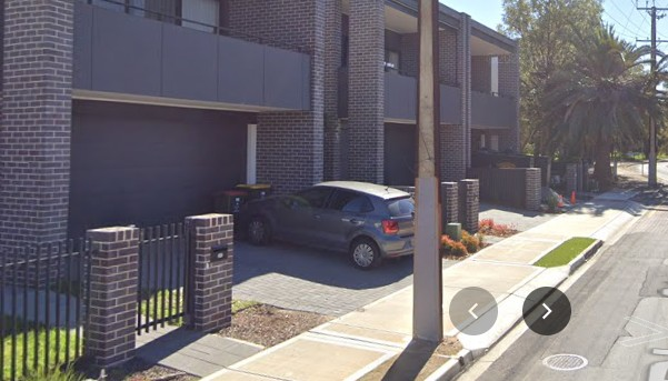
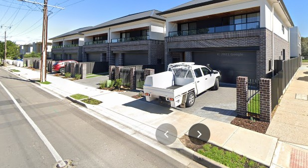
- Driveway space between the road and the dwelling is insufficient in length to accommodate vehicles without their rear ends intruding over footpaths creating nuisance and possibly danger for pedestrians. The length of driveways should be a minimum of six metres and the use of garages for parking should be mandated in the Code and enforced by council
- Garages being used for family space or additional storage instead of for parked cars
- Loss of on-street parking due to multiple crossovers
- Loss of space for street trees to be planted due to the crossovers
These issues are demonstrated by the photos below of recent infill housing built on River Street Marden. They show overhanging vehicles on to the footpath, often exacerbated by the space in front of a garage being used for the placement of garbage bins so that even a small vehicle parked in a driveway may still overhang a footpath, multiple crossovers inhibiting street parking and lack of room for street trees.