


History of St Peters River Park - Planning
5.0 Registers & Planning Regulations St Peters River Park 1982-2022
5.1 Register of the National Estate, Australian Heritage Commission 1982 River Torrens (excluding City of Adelaide) ID6235
The Register of the National Estate (RNE) was established under Part IV of the Australian Heritage Commission Act 1975 and was used to describe a collection of buildings and sites that were worthy of preservation for a variety of reasons.
The National Estate covered natural environments as well as European history and Aboriginal culture.
The Register of the National Estate was compiled between 1976 and 2003 by the Australian Heritage Commission after which the register of 13,000 places was maintained by the Australian Heritage Council.
On the 28 of September,1982, the River Torrens (excluding City of Adelaide) was registered as part of the National Estate.
The entry into the Register of the National Estate stated that the listing covered the whole of the River Torrens from its source in the Adelaide Hills to the coast.
The nomination included the following local government areas as part of the listing – East Torrens, Tea Tree Gully, Campbelltown, Payneham, Walkerville, St Peters, Hindmarsh, West Torrens and Henley & Grange Councils.
The classification adopted by the Register of the National Estate was that the River Torrens represented heritage values of natural and cultural heritage significance.
The was important for two reasons. The first was the ‘Statement of Significance’ which acknowledged the River Torrens as having ‘Indigenous heritage values’.
This highlighted the association between the River Torrens/Karrawirra Parri and the Traditional owners – the Kaurna of the Adelaide Plains.
The River Torrens it was claimed also had geomorphological, geological and ornithological significance.
The listing specifically referred to the River Torrens as an entity and that its boundaries were:
(a) to a distance of 60m from each bank
(b) to a distance of 60m either side of the centre line of the river.
This second component of the listing of the River Torrens defined the concept of a ‘boundary’ for a riverine environment as part of the entity’s conservation and cultural heritage.
This concept of a protective boundary for a riverine environment was the first step towards a progressive understanding of the environmental needs of rivers and waterways. This understanding was reflected in the Corporate Town of St Peters objective from 1912 to acquire land for the purposes of creating a recreation park around the River Torrens.
The listing in the Register of the National Estate and its identification of the River Torrens as having cultural heritage and environmental values influenced the Development Plans of the Corporate Town of St Peters from the 1980s until its amalgamation in 1997.
5.2 Corporate Town of St Peters Supplementary Development Plan 1988
The Development Plan for the Corporate Town of St Peters (1988) was visionary in its arguments informing what principles of development control should apply to the Corporate Town of St Peters, and more specifically to individual zones, including the area around the River Torrens.
The Plan stipulated what conditions and what kind of development was to be permitted. It clearly specified that ‘no development’ could be undertaken within the boundaries of the River Torrens.
“Corporate Town of St Peters Table StP/1Development Plan 1988
Kind of Development
The erection of buildings, change of use of land, earthworks and other construction for the purposes of:
Principles of Development Control
The principles of development control for metropolitan Adelaide apply to the area of the Corporate Town of St Peters. The following additional principles of development control also apply to the council area.
General
1 Development should be in accordance with the Metropolitan Adelaide Plan, MA/4, and St Peters Plan Map StP/1, including that part of the urban area in the adjoining council area. See Fig 5
78 Development should take place in a manner which does not cause soil erosion or the silting of watercourses or create any unstable embankment or cutting.”
The Corporate Town of St Peters Supplementary Development Plan (1988) specified a set of conservation and heritage objectives that would apply to any development within, or which might impact on reserves such as the St Peters River Park:
“Conservation
Objective 16: Protection from waste of water resources
Objective 18: Conservation and re-establishment of vegetation
Objective 19: Protection of biological systems to an extent which enables them to naturally restore or maintain equilibrium. Heritage
Objective 21: Protection of land and items of scientific and natural interest
Objective 24: Conservation of landscapes of aesthetic merit, including sites and localities of natural beauty.”
Extract from Supplementary Development Plan, Corporate Town of St Peters, 1988.
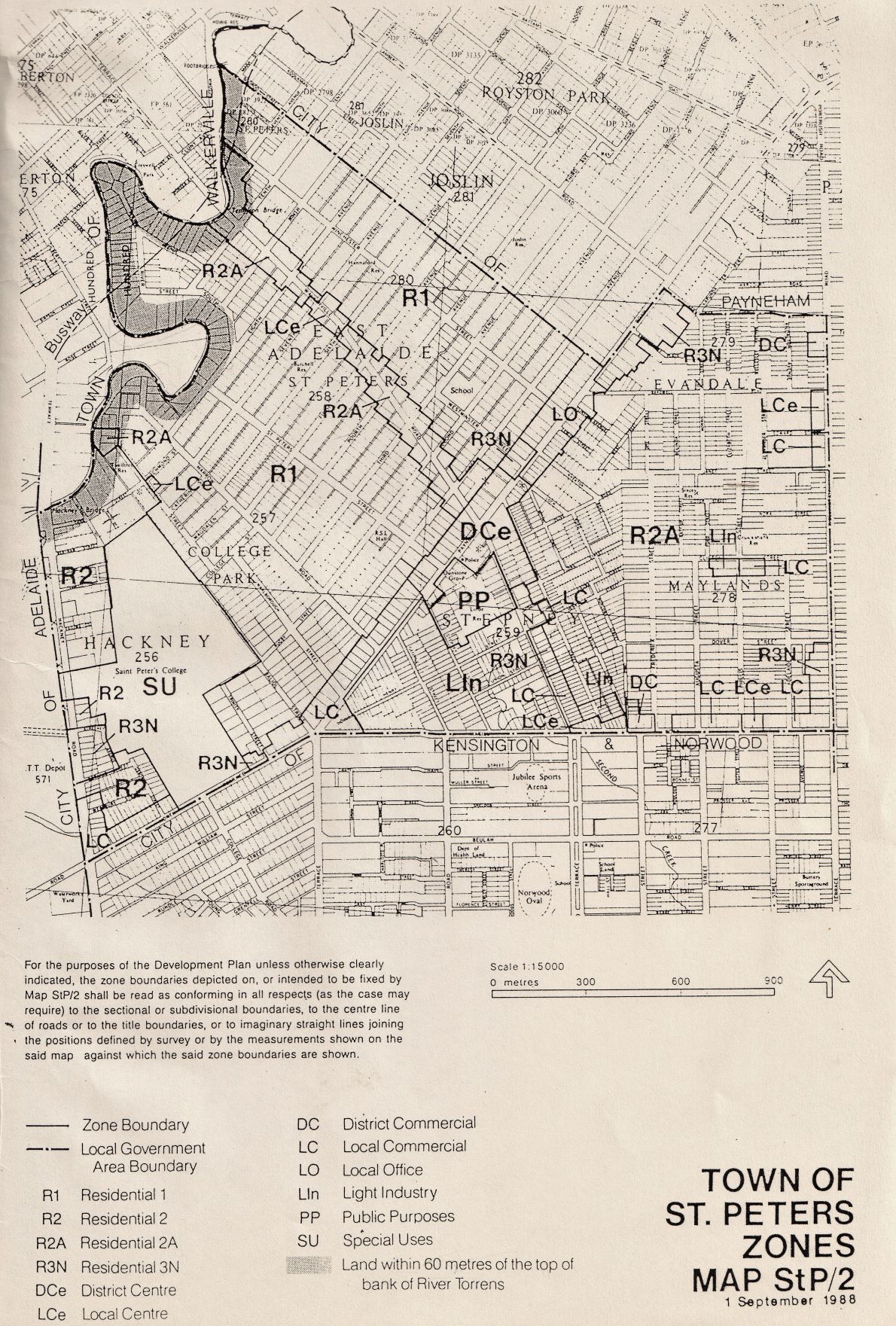
Fig 5 The Plan outlined the principle of development control showing that no new development was to be undertaken within sixty metres of either side of the ‘of the boundaries of the River Torrens or within the River Torrens.’
Supplementary Development Plan, Corporate Town of St Peters, September 1988.
5.3 Development Plan City of Norwood, Payneham & St Peters February 2021
In the intervening years from 1988 until 2021 there were many events which impacted on the St Peters River Park including the 1997 reform to local government boundaries. This saw the amalgamation of various councils across South Australia. Along with this reform to local government, there were various changes to the South Australia’s Development and Planning Regulations and South Australia’s Development Act 1993.
In 1997, following the amalgamation of the former Corporate Town of St Peters with the City of Kensington and Norwood and the City of Payneham became the City of Norwood, Payneham and St Peters. A ‘Community Land Management Plan for the St Peters River Park’ was developed.
One aim of the Management Plan was to ‘stabilise the cliffs by planting appropriate native species along the top and sides of the river cliffs.’ River red gums, blue gums, wattles, melaleucas and she-oaks representative of the original vegetation which once grew beside the River Torrens were to be planted according to detailed landscape plans prepared by Ceilings & Partners for the St Peters River Park.
In February 2021, The Development Plan for the City of Norwood, Payneham & St Peters documented zones, maps and contained explicit written policies which guided property owners and others as to what could or could not be done in the future on any piece of land in the area covered by the Development Plan.
With respect to the St Peters River Park, and adjoining properties, the rules remained consistent with the Corporate Town of St Peters Supplementary Development Plan 1988.
The Development Plan for the City of Norwood, Payneham and St Peters (2021) stated that the St Peters River Park and Linear Park where within the LP(RT) Zone described as Linear Park River Torrens and that no development could be undertaken within sixty metres of either side of the boundaries of the River Torrens or within the River Torrens:
“TABLE NPSP/1
Conditions Applying to Complying Development
Located in the St Peters Area Shown on Map NPSP/1 (Overlay1)
Extract City of Norwood, Payneham & St Peters Development Plan February 2021.
The City of Norwood, Payneham and St Peters Development Plan February (2021) defined the boundaries of the St Peters River Park and conditions of development.
This was particularly relevant to adjoining Allotments on Eighth Avenue, River Street and River Street South, Harrow Road and Goss Court in St Peters. Refer to Fig 6
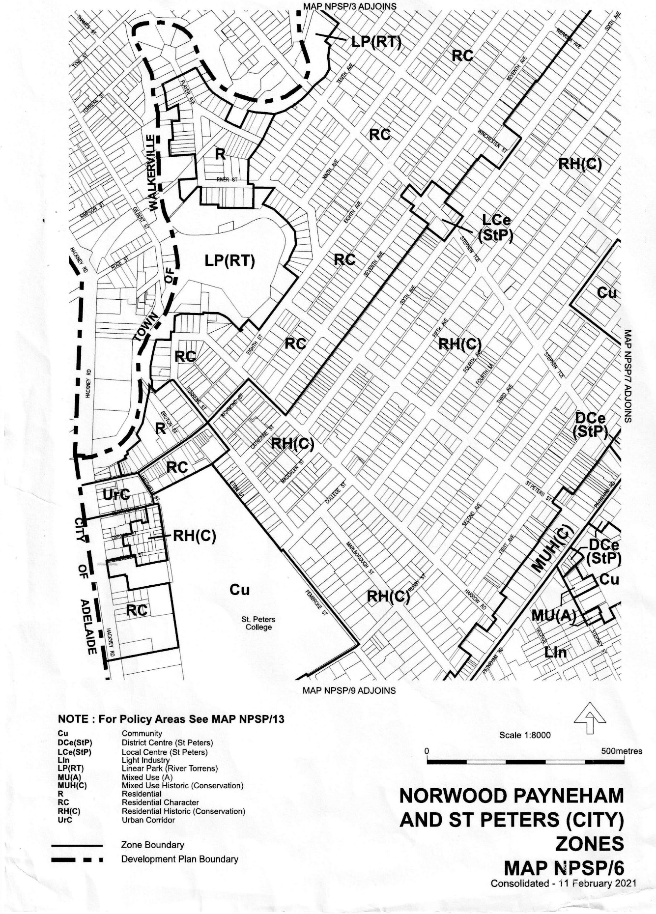
Fig 6 The City of Norwood, Payneham and St Peters Zones Map NPSP/6 (February 2021)
5.4 South Australian Planning & Design Code March 2021
From 19 March 2021, the Planning, Development and Infrastructure Act 2016 (PDI Act) replaced the Development Act 1993. A system of state-wide planning rules were introduced via the Planning and Design Code (the Code). The Code became the single reference point for the state’s planning and development industry.
A significant element of the planning reform involved the revocation and replacing of all 72 South Australian Development Plans with a single state-wide planning rule book, the Planning and Design Code.
The introduction of this new system meant the revocation of the City of Norwood, Payneham and St Peters Development Plan of February 2021 and with it the conditions of development as they applied to the St Peters River Park and adjoining properties.
Prior to 19 March 2021, no development could be undertaken within sixty metres of either side of the boundaries of the River Torrens or within the River Torrens.
However, the new SA Planning and Design Code states:
“that no development can be undertaken within 20 metres of either side of the boundaries of the River Torrens or within the River Torrens”.
This difference in what is now the legal exclusion zone along the River Torrens appears an anomaly within the current Planning and Design Code (the Code) as it relates to the St Peters River Park and makes no allowance for differing factors that impact on the River Torrens from source to sea.
Some of these factors include the physical-geographical factors, climate variability and river engineering structures that have historically modified the natural river and river flow including road works, mining, dredging, diversions, cofferdams, channelization, levees and flood control works.