


History of St Peters River Park - Brief History
6.0 Brief History of St Peters River Park
Following Colonel Light’s survey of 1839 of Country Sections District B, the 400 acres east of Hackney including Sections 257, 258 and 280 on the River Torrens were owned by absentee English investors.
The land comprising Sections 257 and 280 remained farming country for a generation after European settlement of the new Province of South Australia in 1836. The Register Newspaper commented in 1865 that ‘the proprietor deserves the thanks of all lovers of the picturesque for having left unmolested so many of the gnarled gum trees. Cattle graze on the riverbanks and dairy cows eat the lush grasses by the river.’
a) East Adelaide Investment Company Ltd 1878
It was not until 1878 that the English landlords sold Sections 257, 258 and 280 to speculators John Spence and Arthur Harvey who formed the East Adelaide Investment Company Ltd. Harvey and Spence embarked on an ambitious engineering and capital works program to redirect flood waters from Second Creek into a new outlet at the oxbow bend in the River Torrens via an open drain that would eventually become St Peters Street.
The new genteel subdivision on the reclaimed flood plain was called ‘The Avenues’ and was in the 1880s one of the largest real estate ventures in Adelaide. However, Spence and Harvey were financially challenged by the capital works required to drain the marshy land and for it to be developed.
In 1880, Arthur Harvey, Managing Director of the East Adelaide Investment Company Ltd, advertised in the Adelaide newspapers ‘river allotments for sale only two kilometres from the city’. The only takers in the northern Section of 258 and 280 were sand-miners and carters who progressively quarried the banks of the river for loam, gravel and washed sand. They also felled the ancient river red gums for wood supplies and building materials changing the riverine environment.
In 1880 Mining Captain Samuel Terrell and his sons along with James Matthews purchased lots 738 and 739 in East Adelaide. Their boundary being a diagonal line to the River Torrens from what is now the right-angled bend of River Street. The Gilbert family were also sand carters and lived in River Street.
One of the largest operators was the Bickle family located on the Gilberton side. In 1893, they added Terrell’s land holding to their own. This meant they held all the land that comprised the River Torrens and the land between where the river meandered around the oxbow bend. This land from Gilberton to St Peters was worked as a sand mining business until 1960 when sand mining was not allowed and so it was then sold to the HL & RF Dangerfield and later became ‘Dangerfield’s Rubbish Dump’.
The sand carters and miners had the greatest impact on the riverine environment in the 19th and 20th century. The banks of the River Torrens in St Peters are composed of clayey loam, with seams of sand running out into the riverbed both materials as well as the river gravel were of commercial use. The area around the oxbow bend was mined for over 80 years.
In 1887, Harvey & Spence’s East Adelaide Investment Company Ltd collapsed leaving the underwriter - the Queensland Mortgage Company and the British Empire Land Mortgage & Loan Company as the owner of a large area of land allotments in East Adelaide.
b) Frank Woolley (1861-1941) & British Empire Land Mortgage & Loan Company
Frank Woolley was the South Australian representative of these London-based mortgage institutions and an accountant and land developer. Woolley would play a critical part in deciding the fate of the land bordering the river in the St Peters Council.
In 1912 Frank Woolley advertised the land for sale as ‘the only large piece of land available for building sites within the two-mile radius from the G.P.O’. There began a series of attempts by the former St Peters Council to acquire the river frontage still in Woolley’s hands.
Detailed plans were formulated as early as 1912 by the St Peters Council for the development of the river in the St Peter as a recreational park but did not proceed as negotiations with Frank Woolley and the St Peters Council over the land were not successful.
Consequently, Woolley went ahead with the subdivision of eighty-five allotments from Ninth Avenue to the river within which Player Avenue records the name of his Woolley’s wife’s family from Angaston. A suspension bridge was designed by CF muller and built to connect the new subdivision to Walkerville, the Gilberton Swimming Pool and the tramway. The Swing Bridge was opened on 20 March,1920. However, land sales were slow.
c) Corporate Town of St Peters Council Land Acquisition for Reserve
In 1927 land at the rear of Eighth Avenue and River Street in CT1032/104 concerning allotments 726 to 730 were subdivided in Plan 882 to create a new boundary for portions of the allotments. The centre of the river was the former boundary, but it now was defined as the top of the riverbank.
In 1938, the opportunity arose whereby the Corporate Town of St Peters could purchase some of this land and at a meeting of the St Peters Council on 7 April,1938, it was moved and carried that Allotment 725 to the centre of the river, and Pt Lots 726 to 730 being a portion of the riverbank be purchased by the corporation. This of course was in the area referred to as oxbow bend. Refer Fig3.
The Corporation of St Peters long term plan to establish a recreation park in the area along the river in St Peters was delayed again because of the onset of World War 2 and in the decade after the end of the war 1945 the focus was clearly on nation building.
On 1 March 1954, Adelaide suffered a major earthquake for 20 to 30 seconds, recorded as 5.5 on the Richter Scale at Darlington to the south of the city. It caused damage to three thousand buildings including collapsed and cracked walls, smashed windows and collapsed chimneys in the southern suburbs of Adelaide.
Some houses were reduced to rubble and several city buildings were cracked and damaged including the Adelaide Post Office. Due to a lack of earthquake recording equipment in the 1950s no devices measured the movement of the earth along the River Torrens or in suburbs nearby.
d) River Torrens Embankment Collapse River Torrens Embankment River Street, St Peters 1955
In early September1955, part of the riverbank bordering River Street in St Peters collapsed. Some fencing at the rear of properties adjoining the riverbank had fallen with part of the cliff edge into the river. From the photo which appeared in The Advertiser on 2 September 1955, it appears from the angle of the photograph, the area that comprises the northern bend of the Oxbow of the river along River Street was the location of the collapsed embankments.
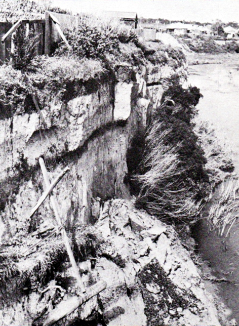
Fig 7 The Advertiser, 2 September 1955
e) The Proposal to Create a ‘Pleasure Ground’
The meeting of the Corporation of the Town of St Peters Council which was held on the 1 September 1955 recorded that:
“Cr Perriam drew the Council’s attention to the erosion taking place on the banks of the River Torrens at the rear of River Street South near Eighth Avenue, East Adelaide. He would like a complete investigation into the matter, as soon as possible, with the view of having the river straightened in this locality.
Cr Perriam moved that the General Purposes Advisory Committee investigate the position.
Seconded Cr Hayter Carried.”
Corporate Town of St Peters Council Meeting, 1 September 1955.
Following the meeting, the members of the St Peter’s Council General Purposes Advisory Committee and the Mayor of the Town of Walkerville inspected the erosion occurring along the River Torrens. They examined the area along both sides of the riverbank downstream from the Tennyson Bridge and at the rear of Eighth Avenue and River Street, East Adelaide.
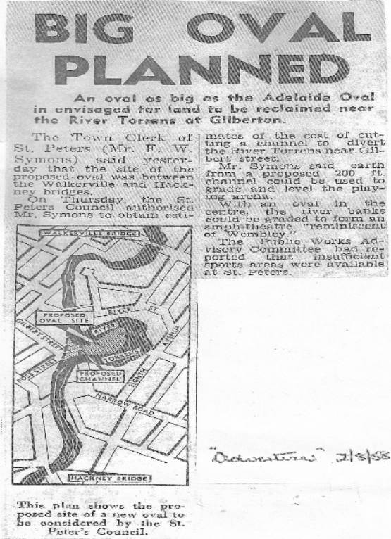
The suggestion was made at the meeting between the two councils to divert the River Torrens by cutting a channel at the rear of Dangerfield’s property. This would enable the River Torrens to run a straight course and to bypass the ‘horseshoe bend.’ It was agreed that the legal ramifications of diverting the river be considered and a further report prepared for the councils’ consideration.
On the 13 October,1955, the Corporate Town of St Peters received legal advice on the proposal to divert the River Torrens and to establish a ‘Pleasure Ground’ on portion of the river in the vicinity of the ‘horseshoe bend’. Further discussions and meetings were held between the Corporate Town of St Peters and the Town of Walkerville.
The Walkerville Council resolved at a meeting on 7 November,1955, that it agreed to Lots 32 and 33 being annexed to the St Peters Council for recreational purposes - provided that the project proceeded and that all expenses were to be paid by the St Peters Council.
Inspired by the Melbourne Olympics of 1956, the grand vision was to convert Dangerfield’s’ Rubbish Dump into a state-of-the art stadium facility and oval for the British Empire Games which were to be held in Australia in 1962. Unfortunately, for the St Peters Council no funding was forthcoming from the Playford State Government.
f) Corporate Town of St Peters Council Land Acquisition for Recreation in 1960-1980
Discussions and representations continued regarding the proposal to divert the River Torrens and create an oval on land which was part of the horseshoe bend. Finally in 1964, the Sir Thomas Playford and the State Government agreed to a grant of 37,000 pounds ($70,000 approx.) towards the cost of works to establish the oval.
The State Government grant was less than half of the estimated costs of 74,000 pounds to acquire land and undertake engineering works to cut a new channel for the River Torrens and to extend the Second Creek drain. Approval was granted from the State Government to the Corporate Town of St Peters to borrow 100,000 pounds for the project.
The South Australian Land Board had estimated that the Dangerfield property was valued at 16,730 pounds but this was rejected by Ray Dangerfield as adequate compensation for his property.
In March 1966, the St Peters Council was able to commence the first stage of the project which was the diversion and extension of the Second Creek Drain from its outfall in centre of the horseshoe bend to a new outlet that would enter the river near the end of Harrow Road.
The new drain would divert floodwaters from St Peters Street outlet to the new outlet at Harrow Road. It was necessary to divert water from the centre of the horseshoe bend which would then enable the re-routing of the River Torrens.
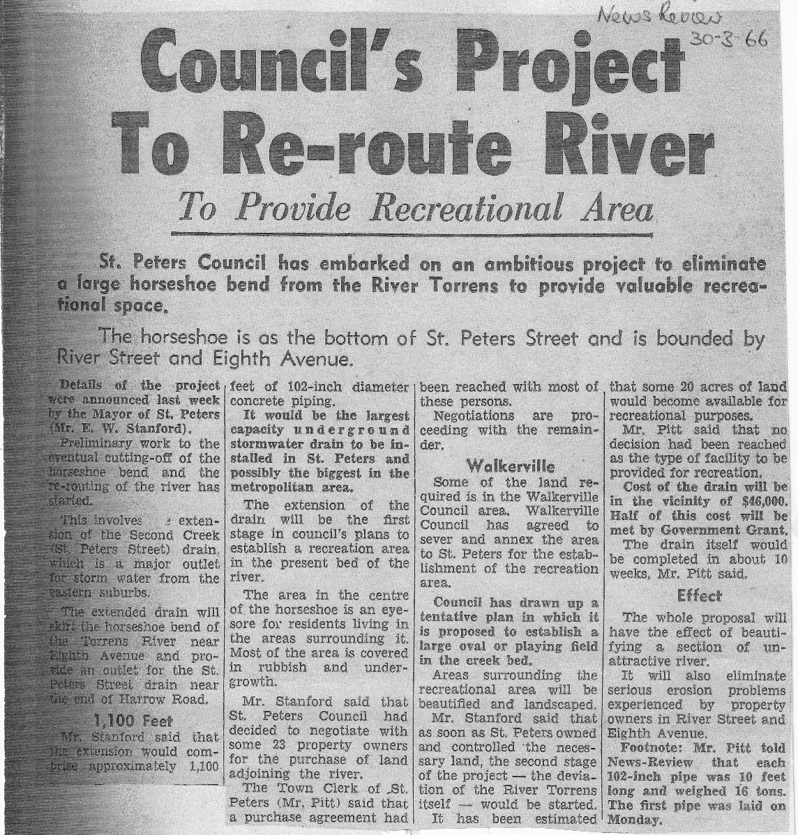
The extension of the Second Creek Drain required the use of huge concrete drainpipes 2.5 metres in diameter which weighed over sixteen tonnes. Work began 20 March 1966 at the ‘horseshoe bend’ and St Peters Street with the drain skirting the river on the southern side from Eighth Avenue along the bank to its new outlet.
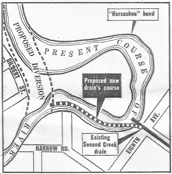
Fig 8 The Sunday Mail 19 March 1966.
g) Kaurna Cultural Sites River Park 1966
On the 25 March,1966, Aboriginal remains were unearthed by the excavations being undertaken as part of the new Second Creek Drain extension project. Given the date that the remains were found, it is believed that they were on the horseshoe bend southside of the river from St Peters Street and Eighth Avenue. The area is currently part of the Billabong.
During the Dangerfield occupation there was an entry point for trucks to dump rubbish from Eighth Avenue down to the river embankment on this southern side. It is believed that this access point provided a starting point for the Second Creek drainage works.
The remains that were discovered in March 1966 were part of a Kaurna burial area at what was a significant ceremonial site – the horseshoe bend. There is little information other than a small new article in News Review, 23 March, 1966, stating that ‘Bone Find at St Peters’ near River Torrens’.
The remains that were retrieved (as there is no information on how many were simply dug over by mechanical means) by the work men digging that part of the trench contacted authorities, in this case the South Australian Police who delivered them to the SA Museum who currently still hold them.
The way in which waters run or drain was a crucial semiotic feature of Kaurna cultural life and its survival, and of the social structures that existed within differing ecological zones. Kauwi referred to rivers, creeks, springs, lagoons, reed beds, estuaries and the coastal waters of Gulf St Vincent.
Rivers, creeks and springs connected the Kaurna to Country through ecology and cosmology. The Kaurna carefully managed the resources of the fragile riverine and coastal environment of the Adelaide Plains for millennia. Life-sustaining Kauwi was essential on earth and in the sky world where the Milky Way was known as Wodliparri. In the dark spaces of Wodliparri was Yurda who was associated with secret-sacred rites and river formation.
The celestial river Wodliparri reflected the Karrawirra Parri (River Torrens) and was a focus for important ceremonial rituals and provided a series of camping sites.
For the Kaurna, waterways were more than lines on a map as these rivers and creeks were ‘songlines’ with rights, responsibilities and relationships that sustained a complex web of life and obligations. Sacred sites were part of this cycle.
Areas such as St Peters and adjoining locations along the Karrawirra Parri provided an environment that supplied crucial resources. There were a number of perennial springs that flowed all year round renewing the river and providing a supply of fresh water to sustain all life in a riverine environment.
In pre-European times Eucalyptus camaldulensis was part of the Karrawirra Parri environment whether the river was permanent or seasonal. These ancient forests were most extensive on grey heavy clay soils of the riverbanks at St Peters and Walkerville and on the floodplains such as that of Felixstow which were subject to frequent or periodic flooding.
Eucalyptus camaldulensis was prevalent where subsoils were moist and heavily laden with clay content. In pre-European times, Eucalyptus camaldulensis lined the River Torrens and its creeks which crisscrossed the Adelaide Plains from the western scarp of the Mt Lofty Ranges.
The ancient forests of Eucalyptus camaldulensis in St Peters and Walkerville supplied the Kaurna with resources for ceremonial artefacts, funeral biers and firewood for burials. The clay soils of the river were also a source of ochre for Kaurna ceremony.
The Karrawirra Parri was also the location for major Kaurna burial grounds because in certain areas the soft sandy soils were easy to excavate to create burial mounds. This was certainly the case in what is now referred to as the St Peters River Park.
Over the next years, more Kaurna remains would be disturbed as part of the St Peters River Park project but given the times, there was little understanding of the significance or cultural relevance of what ‘unearthing Aboriginal remains’ along the River Torrens/Karrawirra Parri really meant or how this would later be interpreted and documented.
h) St Peters Council Land Acquisition 1967 -1972
As the St Peters Council embarked on the first stage of its major River Torrens Recreation Park it pursued land acquisition from 1967. Additional land at the rear of properties on facing River Street and Eighth Avenue was purchased from 1967 until 1969. Land was also purchased on Harrow Road and Goss Court and an area that was part of the Gilbert Street embankment in Gilberton. This land was described as ‘Reserve’ land.
In late 1969, the St Peters Council ran into a stumbling block when a number of landholders would not agree to sell including Roger, Brewster and Dangerfield so the Council was forced to go to litigation to compulsorily acquire the land.
The case ended up in the High Court of Australia where the property was compulsorily transferred to the Corporation of St Peters and the full amount of compensation as decreed by the High Court was paid to ‘Dangerfield & Others’.
As the River Torrens was still subject to flooding, little work was proceeded with however, the development of the Kangaroo Creek Dam in 1969 had a major impact on river flows through out the whole of the River Torrens including the area in St Peters which it was hope would eventually become a recreational reserve. The ‘horseshoe bend’ was periodically subject to increase flows and flooding until the Kangaroo creek Dam was built.
By 1972 all the property that was to be part of the Recreation Ground had been formally transferred into the ownership of the St Peters Council. The last parcel was the land used by Dangerfield as a rubbish dump bound by the ‘horseshoe bend’ in the river. Over a six-year period land had been progressively purchased from twenty landowners to give a total area of ten hectares.
i) The Creation of the River Torrens Recreation Park 1974-1980
In 1974 the St Peters Council announced that subject to further State Government financial help the next stage of developing the recreation park was being planned. On the 6 November 1976, the Mayor of St Peters Max Otto announced that the State Government had agreed to fund two thirds of the $300,000 to develop the reserve and to the divert the River Torrens in a straight line by passing the ‘horseshoe bend’:
“The development involves the diversion of the River Torrens by cutting across the
neck of the loop, and the formation of a level area that will be grassed and available for use as playing fields. The course of the river will be about seven hundred metres shorter when the neck is cut out.
The first three hundred metres of the loop will be filled in, but the rest will be retained in its natural state. Though cut off from the main stream by the diversion, the loop will be fed with the river water by underground pipeline. After forming the creek and a lake in the loop, this water will flow back into the river through another pipeline.
Two weirs will be built in the river to make allowance for the difference in fall resulting from the removal of the loop. The Weirs will hold back a body of water. It is hoped that engineering work will be finished by May 1977.”
The Advertiser, 6 November,1976.
Engineering works saw major landscape disturbance and modifications including the diversion of the River Torrens and the cutting off - of the horseshoe bend. (This area was later known as ‘The Billabong.’)
The diversion of the river it was claimed would manage bank erosion but there were differing opinions on this matter.
The President of the Royal Australian Institute of Architects, BJ Vogt, warned against interfering with the course of the river and called for further studies to be conducted on the proposal as it could worsen erosion ‘the project should be more than-a-straight forward engineering job.’ (The Advertiser, 23 March 1974).
The St Peters Council proceeded with the diversion and two weirs were built to control the flow of water and the water level in the new main river channel. These were the Pickering Weir at the upstream end of the diversion and at the lower end, the Pitt Weir.
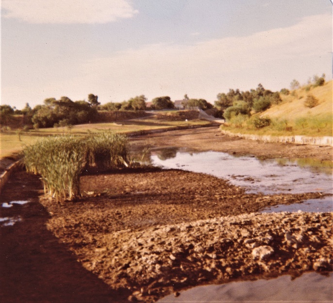
Fig 9 View of the new river channel from Pickering Weir looking south to Pitt Weir 1977
k) The St Peters River Park and The Billabong 1980-2003.
On the 9 March 1980, the Mayor of St Peters, Max Otto officially named and opened the St Peters River Park which included the dedication of the Lindsay Perriam Oval. It was named after the former Mayor Lindsay Perriam who dedicated much of his time in office to making the recreation park a reality. The two weirs were named after Donald Graham Pitt, former Town Clerk of St Peters Council and Allan Frances Pickering, former Town Clerk of St Peters Council.
It was declared that the aim of the St Peters River Park was to provide the community with a place for recreation of an informal and passive kind within a natural environment. It was hoped that by revegetating the park with original native species that this would encourage the return of native wildlife to the park.
In 1985, the St Peter’s Council applied to the Australian Bicentennial Grants to further develop the St Peters River Park and to create an ‘urban billabong’ in an old section of the River Torrens known as the ‘horseshoe bend’. This project was inspired by the listing of the River Torrens on Register of the National Estate by the Australian Heritage Commission in 1982.
The St Peters Council grant application specifically stated that it wanted to create an ecosystem that was as a living example of what might have existed before European settlement. The Council received $10,600 from the Bicentennial Authority and a further $86,000 from the Commonwealth Employment program with a contribution by the St Peters Council the budget for the Billabong Project totalled $110,000.
The South Australian Environment and Planning Minister Don Hopgood officially opened the Billabong on 16 October,1988. A boardwalk was constructed around the edge of the old river, native trees including River Red Gums were planted while introduced species of olive, willow and ash trees were removed, reed growth was sympathetically controlled, new aquatic and bushland plantings encouraged, and water flow into the area was to be improved through pumping.
Following the opening interested residents formed the ‘Friends of the Billabong’ on 24 October,1988, which became an advisory committee of the St Peters Council. The Friends of the Billabong under the Chairmanship of Dr Colin James were responsible for continuing the program of replanting and caring for the Billabong and making sure that the park retained its aim of passive recreation.
In 1997, the newly formed City of Norwood, Payneham and St Peters Council commissioned a new study to prepare a detailed concept plan to return the Billabong to its pristine pre-European settlement state.
The concept documented dense River Red Gum plantings and a dense understory of shrubs along the top of the embankment around the whole of the horseshoe bend. The stated aim was to screen out housing and roadways and to provide an upper story corridor for bird life and to assist with stabilising the embankments.
At the same time, the Torrens Catchment Water Management Board was seeking opportunities to trial the construction of wetlands along the River Torrens to improve the ecology and water quality of the river and to reduce the amount of rubbish entering the river.
This wetlands project would also entail major ground works, diverting flows from Second Creek and reconfiguring drainage and installation of trash racks in the St Peters River Park.
Working in conjunction with the City of Norwood, Payneham & St Peters the Billabong Wetlands project received $950,000 from the Torrens Catchment Water Management Board, with a $200,000 grant from the Federal Government’s Natural Heritage Trust program.
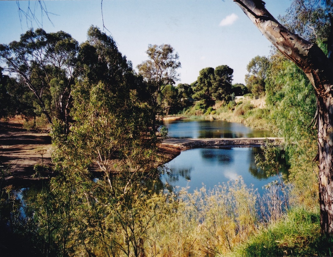
Fig 10 View to River Street looking north across The Billabong March 2001
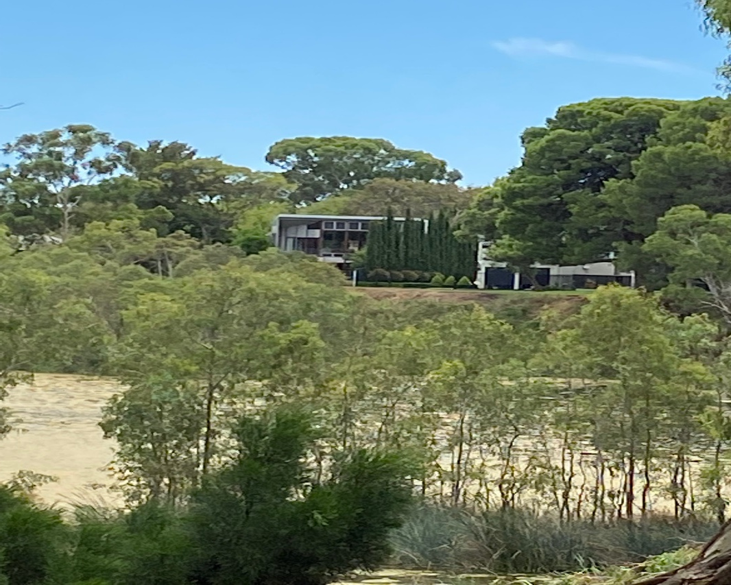
Fig 11 Current view to River Street looking north across The Billabong March 2022.
Note the severe algal bloom and that many trees have been removed from the reserve embankment area at the rear of a number of River Street properties.
The official opening of the Billabong Wetlands occurred on 30 March 2003 and was launched by the South Australian Minister for Environment John Hill.
This project would not be the final project that would be undertaken to reshape the Billabong and the St Peters River Park in the 21st century but it was the closing of one chapter in a long history that had started in 1912 with the idea of creating a recreational park in St Peters by the River Torrens.